


Technology Trends
Emergencies come unannounced. And whether it is a fire, medical emergency or natural disaster, the ability to navigate indoor spaces seamlessly can mean the difference between life and death. Traditional signage can provide guidance to exits and indicate meeting areas, but in times of stress and panic, indoor navigation technology means that instructions can be as close as each person’s smartphone. In this article we will explore how indoor navigation technology in emergency response are transforming emergency response, and some helpful guidelines to follow when choosing a technology provider.
Fundamentally, It is imperative that each facility has a comprehensive emergency response plan in place to ensure the safety of the building’s occupants and property.
What is an Emergency Response Plan?
According to the Canadian Centre for Occupational Health and Safety, an emergency response plan “specifies procedures for handling sudden or unexpected situations. The objective is to be prepared to:


- Prevent fatalities and injuries.
- Reduce damage to buildings, stock and equipment.
- Protect the environment and the community.
- Accelerate the resumption of normal operations.
And emergency response plan includes:
- All possible emergencies, consequences, required actions, written procedures, and the resources available.
- Detailed lists of emergency response personnel including their cell phone numbers, alternate contact details, and their duties and responsibilities.
- Floor plans.
- Large scale maps showing evacuation routes and service conduits (such as gas and water lines).
Source: Canadian Centre for Occupational Health and Safety
What is the Role of Indoor Navigation Technology in Emergency Response?
Let’s explore the various ways location technology enhances emergency response:
1. Quick and Accurate Routing
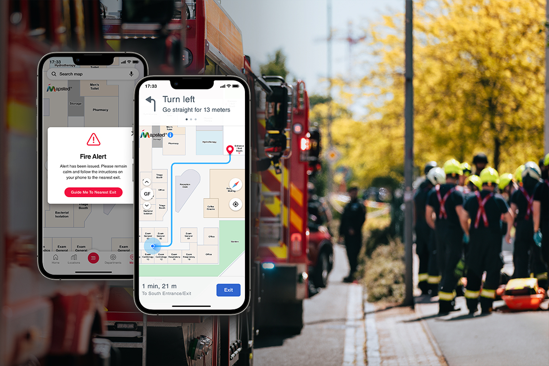
Mapsted’s hardware-free indoor navigation systems provide first responders with the fastest and safest routes to their destinations within a building. This emergency management technology ensures that responders can reach affected individuals or critical locations without any delays. For the public, Mapsted’s systems provide clear evacuation guidance to the nearest exit, turn-by-turn directions on their smartphones, ultimately reducing panic and confusion.
2. Real-Time Location Tracking
Real-time location services are important in emergencies. These services allow responders to:
- Monitor Responder Movements: Ensure no responder is lost or unaccounted for.
- Guide Evacuations: Direct people away from danger efficiently.
- Locate Distressed Individuals: Quickly find those in need of assistance, such as people trapped or injured.
3. Comprehensive Indoor Mapping
Mapsted’s indoor mapping solutions provide detailed and updated maps of building interiors. These maps are essential for both responders and the public to understand the building layout, identify exits, and locate safe zones. Continuous updates ensure accuracy even in dynamic situations.
4. Integration with Emergency Systems
Modern indoor navigation systems can effortlessly integrate with existing emergency response technology like fire alarms and security networks. This integration enables the automatic alerts, real-time updates, and coordination with emergency services, boosting overall response effectiveness.
Mapsted’s Role in Enhancing Emergency Response
Mapsted’s hardware-free indoor navigation technology is leading the charge of transforming emergency response. With over 100+ patents and a decade of experience, Mapsted leads the indoor location-based services industry by providing exceptional solutions that give accurate and reliable indoor positioning without the need for external hardware like Bluetooth, beacons or Wi-Fi.
Mapsted’s technology advanced data-fusion and self-learning algorithms deliver precise real-time location services within a 1-5 metre accuracy level. This makes it perfect for emergency situations where fast and accurate navigation is crucial, highlighting the indoor navigation technology benefits in emergency situations.
Implementing Indoor Navigation Systems
The implementation of indoor navigation systems for emergency response requires careful planning and execution. Take a look at the key steps involved:
- Assessment and Planning. Conduct a thorough assessment of the indoor space. Identify key points of interest, exits, potential hazards, and areas where navigation support is vital. Mapsted’s technology uses AI and data fusion to create precise and comprehensive digital maps of indoor spaces, ensuring that all areas are covered and accurately represented.
- Technology Selection. It is important to choose the right emergency management technology for your facility or space. Mapsted offers a hardware-free, beacon-free solution that eliminates the need for additional external devices like Bluetooth beacons or Wi-Fi, making it a cost-effective and maintenance-free option.
- Installation. Unlike traditional systems that require costly and extensive hardware setup, Mapsted’s solution uses advanced algorithms and AI to calibrate the property efficiently. This involves taking digital data points through minimal hardware, streamlining the installation process.
- Mobile Application Development. Develop a user-friendly mobile application that will serve as the user interface for the indoor navigation system. Mapsted’s cross-platform compatibility allows integration into existing mobile apps, web portals, and kiosks, providing smooth and exceptional navigation experiences across multiple devices.
- Training and Testing. Mapsted provides ongoing support and updates to the staff or first responders, ensuring that the navigation system remains accurate, updated and effective over time.
- Integration with Emergency Services. Mapsted’s solution seamlessly integrates with various emergency services, providing real-time updates and quick alerts automatically during emergencies, which improves the overall response efficiency.
Conclusion
Without a doubt, the impact of indoor navigation technology in emergency response is game-changing. These systems, equipped with indoor mapping solutions, real-time location services and accurate indoor positioning, have the potential to minimize chaos and most importantly save lives during indoor emergencies. This showcases the indoor navigation technology benefits in emergency scenarios. Ready to revolutionize emergency response in your building? Go for the life-saving power of Mapsted’s indoor navigation technology. Book a free demo today and let our experts guide you. Want to explore further? Read our insightful articles on Indoor-Outdoor Navigation: Challenges and Best Solutions for 2024 and Mapsted Location Technology Solutions.
Frequently Asked Questions
Q1. How does indoor navigation technology enhance emergency response?
Ans. Indoor navigation technology provides real-time location tracking, efficient routing and detailed indoor for fast and accurate responses in emergency. Mapsted’s hardware-free solutions ensure uninterrupted functionality without additional hardware.
Q2. What components make up an indoor navigation system?
Ans. Key components include advanced data-fusion technology, cloud-based infrastructure, mobile applications and seamless integration with emergency systems. Mapsted’s solutions also use sensors like accelerometers and gyroscopes to provide precise positioning.
Q3. How do real-time location services benefit first responders?
Ans. Real-time location services allow first responders to monitor movements, guide evacuations, and locate distressed individuals fast and efficiently. Mapsted’s systems provide precise and reliable data for better situational awareness and coordination.
Q4. What future technologies will impact indoor navigation?
Ans. Future technology in emergency management includes augmented reality, IoT integration, artificial intelligence, and smart buildings. These advancements will boost the capabilities of indoor navigation systems, making them more seamless, effective and intuitive during emergencies.
Q5. How can businesses implement indoor navigation systems?
Ans. Businesses can implement these systems by first selecting the right technology – look for none other than Mapsted. Its solutions provide flexibility and ease of deployment, ensuring a smooth implementation process.


