


Technology Trends
Indoor mapping has been available for years but is only recently excelling in innovation and user-friendly interfaces. Floor plans of large spaces such as shopping malls, universities, airports, hospitals and more can be transformed into digital representations that can be accessed by visitors and management alike, with not only navigation capabilities, but also powerful analytics and building-intelligence gathering possibilities.
With so many cool features, one would assume the process is hard and may require some sort of special map maker. This is false. Creating a map may seem like a daunting task but in reality it just requires the right information and following some key steps. This article serves as a simple guide on how to create indoor maps.
How Does Indoor Mapping and Navigation Work?
Indoor map technology combines the power of GPS with a highly accurate digital mapping and indoor positioning systems. Indoor maps not only provide convenience for users but also for the companies managing the property. Visitors can easily download the application or open it on a web or mobile device to view a digital representation of the building and can virtually roam around and search the building, as well to receive live updates in real time. Executives and operations managers can easily use indoor maps to make updates, guide important decisions, and plan resources and facilities accordingly.


How to Create Indoor Navigation Maps
Here are 7 steps to follow when creating your digital maps:
1. Have Clear Goals
When creating indoor maps, it is crucial to define your goals early on so that you know what to look for in an indoor mapping service. For example, if you want your map to be usable by employees on a mobile device or by visitors at a kiosk, make sure your indoor map service can connect to these apps with well-documented SDK and APIs. If you want to incorporate Internet of Things (IoT) data or HTML content from the web, make sure your map can pull in that information on a regular basis.
2. Define Your Use Case and Understand the Benefits
Depending on your space, industry, or workforce, you might have a range of different goals for your indoor map design. Some common reasons for creating an indoor map include:
- Better space management and planning
- Increased productivity
- More efficient energy usage
- Increased safety and security
- Data collection and management
- Better visitor/user experience
3. Find the Best Indoor Mapping Solution Provider
The next step in creating a map is to decide on an indoor mapping solution and indoor map editor that best suits your needs. When choosing indoor mapping solutions, there are many things to consider:
- Years of experience
- Clients they have worked with
- Square feet mapped
- Support services provided
- Ease of scalability
- Quality of technology
4. Initiate Your Floor Plan
The features within different indoor navigation programs will be different. Each service provider’s process of creating indoor maps will be different however, one thing is common for all providers- your indoor 2D map (floor plan) is the basis for your 3D indoor mapping project.
Consistency is key when it comes to creating an indoor map. When creating your indoor map make sure you create them at scale by leveraging automation. You can convert 2D maps into 3D indoor maps by digitizing all mapping data in 2D vector polygons and rendering them into 3D from multiple perspectives.
When you’re creating an indoor map, your maps should be geo-referenced to real-world measures so that they appear “in place” and aligned with real-world coordinates. It is crucial to keep your indoor map accurate and consistent. Precise location data and accurate maps provide clarity and consistency and save time in the future when you’re adding new details and location details.
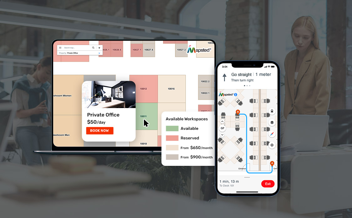
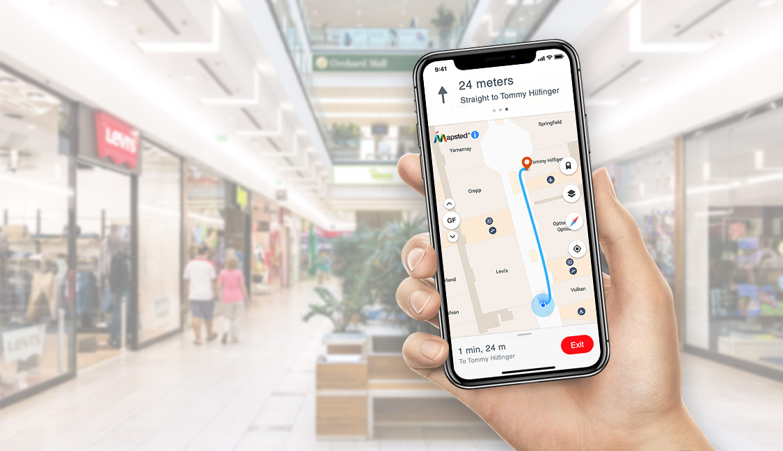
5. Locate Key Points of Interest
When getting started with your indoor location mapping, your solution should allow you to introduce Points of Interest (POIs). They fill your map with features that allow people to navigate with ease. POIs can include (but are not limited to):
- Vending machines
- ATMs
- Payphones
- Bathrooms
- Security desks
- Elevators
- Help desks
- Stairs
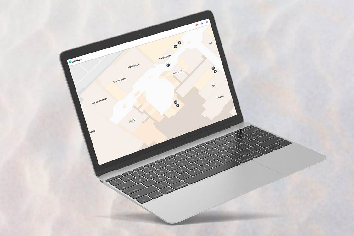
POIs can improve your indoor map and navigation experience by helping visitors navigate quickly between areas of interest. Your indoor map can include a legend to have a symbol that represents the service, which allows users to easily locate what they need and where they can be found on the map.
6. Collecting Location Details
The next step in learning how to create your own indoor navigation map is to collect all other location details about your building. If you’re creating an indoor map for a mall, for example, you would need to collect all the shops available in your mall, categorizing them into their specific type and audience. This type of information is extremely important to help customers navigate through your shopping centre. The more detail the more robust your map will be.
By creating a list of your location details, the indoor map maker service can easily upload the details onto the system. You can also make future changes with ease.
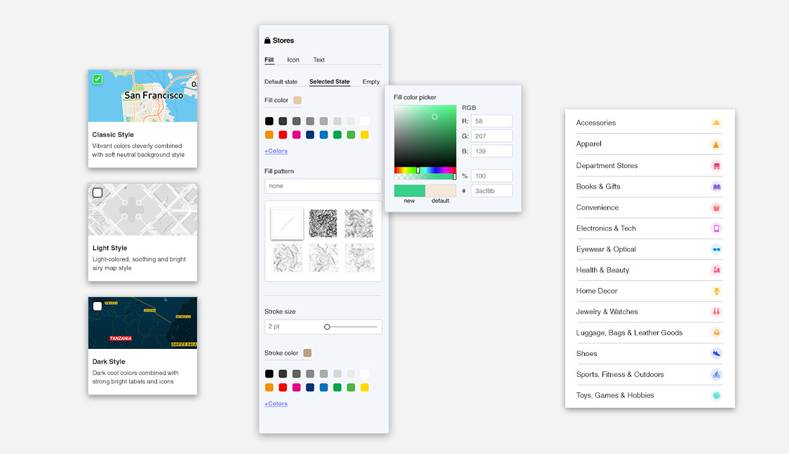
7. Incorporate Your Branding
Your branding plays a huge role in the success of your indoor map. Your brand is how your visitors view your products. Make sure you can add your logo to the indoor map. This ensures the map is branded and reflects the style of your company. In addition to your logo, you may want to consider using the same typography and colours as your brand. Mapsted Maps Studios enables users to fully incorporate their branding into their maps.
To improve your indoor mapping project, utilize advanced features such as real-time updates and analytics to complement it. This enables visitor pattern identification, resource optimization and incorporation of data-driven decision-making. Also, interactive elements like AR or 3D visualizations can be used to improve user experience and make navigation engaging and intuitive.
Do not forget to evaluate the scalability of your mapping solution. As your space or business grows, the mapping system should easily adapt to accommodate new areas, features, and data. This forward-thinking approach ensures that your investment continues to deliver value over time.
With a solution like Mapsted, you won’t only streamline the process of creating but also get ongoing support and innovative tools that help your map to be well ahead of others.
Conclusion
Creating an indoor map provides your visitors with important information about your venue. With the right provider, it can be a simple process that offers countless benefits to those who visit your space, and your business operations. Following these 7 simple steps will help you learn how to create indoor maps. But your best step is contacting Mapsted for a quick demo of our innovative technology with a purpose. If you enjoyed this blog, you may also enjoy our short video on Empowering Every Step with Intelligent Navigation and our blog on The Capabilities of Indoor Positioning Analytics for Facilities Management.
Frequently Asked Questions
Q1. Why do you need an indoor map?
Ans. Indoor maps can help you visualize various indoor spaces and provide navigation to visitors. They can help with space planning and optimization as well as assist management in making updates to the current map landscape.
Q2. What is an indoor map?
Ans. An indoor map is a detailed digital map that is generally created with the help of map-making software. Mapsted is an expert in map-making with its own proprietary in-house map-making software.
Q3. Can I create an indoor map on my own?
Ans. Sure! Just follow the 6 simple steps in this article and find a suitable map maker to bring your indoor map to life.
Q4. Once I have my indoor map what can I do with it?
Ans. Depending on the use case of your map, it can be accessed in a variety of ways and used across mobile, websites, kiosks, and all other smart devices.
Q5. What resources are available to support me if I want to make my own indoor maps?
Ans. Try checking out https://developer.mapsted.com/mobile-sdk/ for a comprehensive understanding of how indoor maps are built by developers.


