


Technology Trends
Let’s face it, location-based technology is widely known for its mapping, wayfinding, blue-dot navigation, proximity marketing, and location analytics possibilities. And indeed, the potential benefits these services can bring to almost every industry is immense. But one of its most compelling use cases is often overlooked: its potential to save lives and reduce emergency response times. Location-based technologies in emergency preparedness is changing how organizations plan, respond and recover from crises. From natural disasters to active threats, this technology enables real-time emergency response by pinpointing the location of individuals and guiding them to safety. With accurate indoor positioning and emergency response technology, responders can locate people faster, send targeted alerts and allocate resources more effectively.
Innovations like Mapsted’s hardware-light solutions also overcome key challenges like privacy and infrastructure dependency. Whether you’re exploring how maps help in emergencies, how to check someone’s location or how can we locate anyone in an emergency situation, this blog explores the transformative role of location-based technologies in building safer, smarter emergency-ready environments.
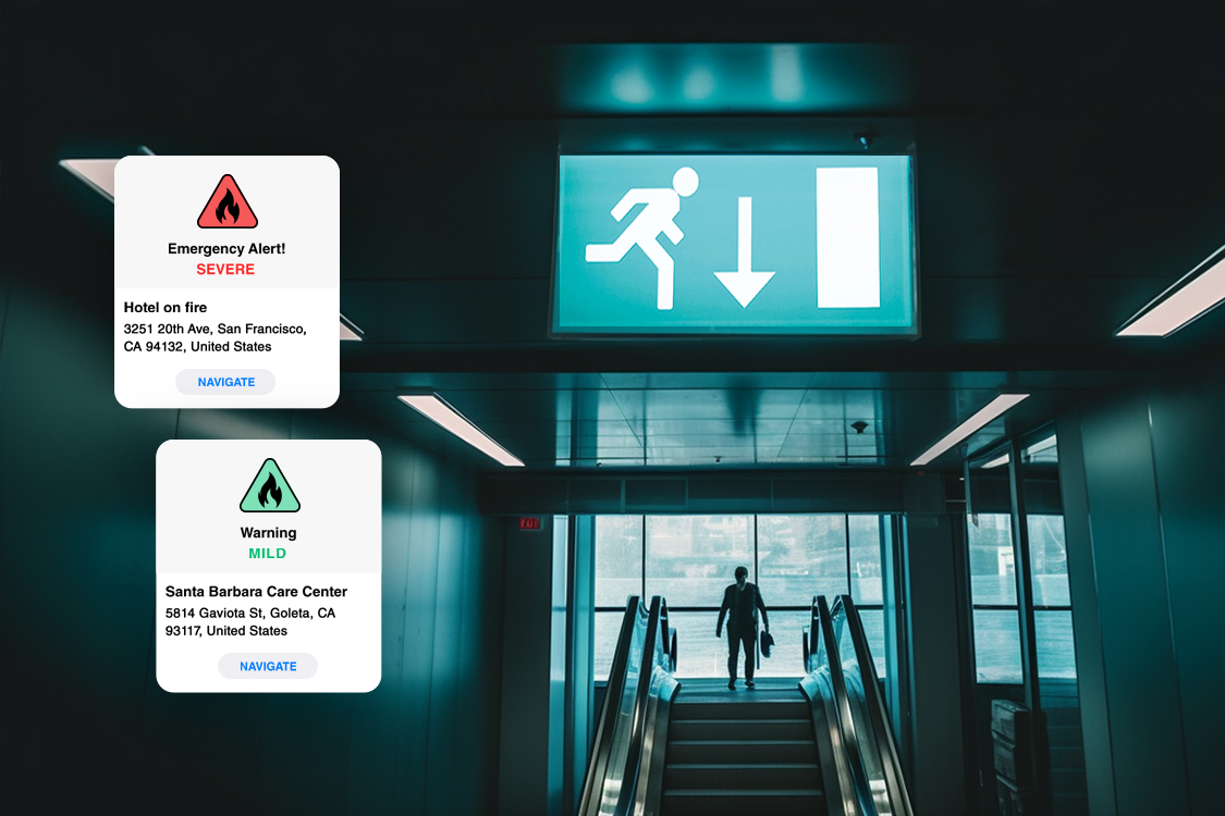
Picture this: An emergency occurs and chaos ensues immediately. In such a scenario, waiting for help to arrive may not be the best option. Instead, location-based technology can enable you to know where to go and how to get help quickly. While emergency teams may need time to plan the safest way to reach victims, location technology can guide users to safety and broadcast their location to expedite rescue efforts.
Indoor location technology is particularly beneficial because it provides real-time information about and to users. This means that their exact location can be accurately marked on a map, allowing them to understand their surroundings and choose the most efficient and safest route. This also allows facilities managers and risk management teams to have an exact count of who is in the building and where they are located.


The Key to Quick and Effective Emergency Response
Today, location-based technology is being widely used by both rescue teams and civilians to stay safe during natural disasters and emergency situations such as terrorist attacks. This technology can make significant strides in situations where every second counts.
To fully understand the potential of location-based technology in emergency situations, consider the following applications:
• With location tech, emergency plans can be created with greater precision. This technology can help create more robust emergency preparedness plans without the need for guesswork.
• Automated emergency alerts are another key application of location-based technology. By using real-time location data, priority notifications can be sent to those within affected areas to warn them of potential dangers.
• The combination of location tech and IoT devices takes things one step further. Their synergy can reduce the rescue workers’ efforts to determine the exact number of people inside a building and monitor air quality to ensure the safety of building occupants.
How Can Location-Based Technology Improve Emergency Preparedness?
Having a location-based technology is akin to possessing a key that unlocks the gateway to:
- Faster emergency response times: Location-based technology can help first responders quickly locate and reach people in need during an emergency, reducing response times and potentially saving lives.
- Improved situational awareness: By providing real-time location data, location-based technology can help emergency managers and responders better understand the scope and severity of an emergency, as well as the locations of affected individuals and critical infrastructure.
- Better resource allocation: Location-based technology can help emergency managers and responders allocate resources more efficiently by providing real-time information about the location and status of emergency personnel, equipment, and supplies.
- Enhanced communication and coordination: Location-based technology can improve communication and coordination between emergency responders and affected individuals by enabling targeted alerts and notifications, and facilitating two-way communication.
- Increased accuracy and precision: Location-based technology can provide highly accurate and precise location information, even in complex indoor environments, allowing emergency responders to navigate and search for people in need.
Comparing Location Technologies: Which One Fits Your Needs?
While location-based technologies such as GPS, Bluetooth, and external Wi-Fi have proven useful in emergency preparedness, they do have some practical drawbacks. Privacy concerns are among the most significant challenges facing experts in the field. The potential misuse of data and the lack of secure technology make them ineffective for widespread global use. Additionally, technical barriers exist, such as the need to train users and backend staff on how to configure the application and hardware.
Therefore, it is essential for facility managers and decision-makers to choose a location technology that is better in every aspect. This technology should not require additional hardware, yet has the ability to overcome privacy concerns and scale implementations without incurring exorbitant costs. As you navigate the decision-making process for selecting the right location-based technology, it is crucial to carefully consider all options available.
Mapsted: Your Ultimate Partner in Emergency Preparedness
Wonder why so many leading brands choose Mapsted as their mapping partner? We prioritize the safety and security of users without making any compromises. The team of our expert engineers has spent years perfecting our innovative technology to create a smart ecosystem within venues, putting user safety first.
Our cutting-edge technology seamlessly integrated into your venue gathers visitor location and behaviour data without compromising their privacy. Our enterprise-ready patented solution gathers information in real-time, enabling you to monitor traffic flow and floor use patterns and direct staff to alleviate bottlenecks at hotspots.
Mapsted’s technology is highly customizable, allowing end-users to receive automatic notifications about nearby events as soon as they are detected on a virtual floor map. Unlike other location-based technologies that rely on proximity to a signal source, Mapsted uses data points from multiple sources to ensure unparalleled accuracy, even in signal dead zones or transition points within buildings.
The Pinnacle of Innovation with Mapsted
At Mapsted, we are protected with powerful patents, including crowdsourced passive positioning and calibration, magnetic landmark method, crowd-sourced pedestrian localization, timeout-based localization, server-based mobile device monitoring in crowd-sourced pedestrian localization, and neural network training for mobile device RSS fingerprint-based indoor navigation.
What sets us apart is that these methods utilize signal data from existing infrastructure, such as
- Wifi
- Bluetooth
- Gyroscope
- Magnetic fields
- GPS
- Predictive motion
- Accelerometer
- Cellular networks.
By gathering data from such diverse sources, our technology is highly adaptable, and dependable and can easily be integrated into an existing ecosystem, making it a robust solution for your location-based technology needs.
Final Thoughts
Location-based technology has revolutionized emergency response by providing precise and accurate location data that can help save lives. With the ability to navigate users to safety during critical situations and speed up rescue efforts, it has become an essential tool in emergency response. Mapsted’s enterprise-ready solution is a prime example of this technology, delivering highly accurate and precise location data while also prioritizing customer privacy. The technology integrates seamlessly into venues and can be customized to meet unique requirements, making it a reliable and adaptable option for location-based technology needs. With Mapsted’s technology, you can monitor traffic flow, track visitor movements in real-time, and reduce the workload of rescue teams by determining the number of individuals within a facility.
Investing in location-based technology isn’t just about being prepared for emergencies – it’s about saving lives. Find out how you can make a difference today by contacting Mapsted. If you would like to know more about what Mapsted technology can do for your business, read our blog on How Smart Building Technology Makes Smart Buildings Even Smarter and this short video introducing you to Mapsted.
Frequently Asked Questions
Q1. What is location-based technology, and how does it work?
Ans. Location-based technology is an electronic system that utilizes devices such as GPS, Bluetooth, WiFi, and other sensors to determine the location of people or objects. This technology works by sending signals to these devices and receiving their responses to determine their precise location.
Q2. What are the benefits of using location-based technology?
Ans. Location-based technology can be used for a variety of purposes, including emergency response, navigation, and monitoring. Its most significant benefit is its ability to accurately pinpoint the location of individuals or objects, enabling faster and more efficient emergency response times.
Q3. How does Mapsted’s location-based technology differ from other solutions?
Ans. Some effective promotions include offering coupons, loyalty rewards, personalized recommendations, and exclusive deals for customers who check-in or share their location with your store.
Q4. Can Mapsted’s location-based technology be integrated with existing systems?
Ans. Yes, Mapsted’s technology can be easily integrated into an existing ecosystem, making it a versatile and robust solution for location-based technology requirements.
Q5. What is emergency information technology and how is it used?
Ans. Emergency information technology refers to digital systems that gather, process and share data during emergencies. It includes tools like location tracking, emergency alert systems and data dashboards that help first responders and decision-makers act quickly and accurately in critical situations.
Q6. How does location-based technology support real-time emergency response?
Ans. Location-based solutions enable real-time emergency response by providing instant location data of individuals, hazards and responders. This technology allows emergency teams to assess conditions, plan rescue routes and prioritize responses without delay, especially in indoor or high-density environments.
Q7. Why is indoor location technology important for emergency situations?
Ans. Traditional GPS often fails indoors, but indoor location technology fills that gap by using alternative signals like Wi-Fi, gyroscopes and magnetic fields. This allows organizations to track people inside complex buildings, enabling better emergency preparedness and faster evacuations.
Q8. How do location-based systems enhance technology in emergency management?
Ans. Technology in emergency management benefits greatly from location-based systems. These technologies provide dynamic data that supports situational awareness, resource tracking and targeted communication—making emergency plans smarter, faster and more effective.
Q9. Can location-based technology help determine how to check someone’s location in real time?
Ans. Yes, modern systems can help organizations check someone’s location during a crisis without breaching privacy. Solutions like Mapsted’s offer secure, hardware-light tracking that provides real-time location visibility to emergency responders while maintaining user confidentiality.
Q10. How can maps be helpful in emergencies?
Ans. Maps—especially digital, real-time maps powered by location-based technology—are essential in emergencies. They help visualize evacuation routes, identify hazard zones, track individuals and guide rescue teams to affected areas. In indoor settings, intelligent maps can display live movement, highlight safe exits and provide instructions, dramatically improving safety and response time.


